
����λ�ã��O�����dվ �� ��Xܛ�� �� �����̌W �� ���ƽ̌W �� 3DFieldPro
3DFieldPro���d V2.7
�є����D�Q�ɵȸ߾��D��ˮ��D �؈D�ʴ_��λ- ܛ����B
- ���d��ַ
- �W���uՓ
3DFieldPro�@���y�L������Ԍ������D�Q�ɵȸ߾��D��ˮ��Ŀ���y�L�档����X��Y��Z�����c���뵽���˷���ֱ�ǻ��������Π��߅�硣��Ҳ������ƽ���ϡ�2D��3D�����M�ϡ��ڰȸ߾��D�ϡ������С�Ą����D���@ʾ�����c��֧����Ϣݔ����ʽ���� EMF, WMF, BMP, JPG �� PNG ��ʽ���D��ο����@ʾ����Ŀ䛽Y���������棬�@�ӿ���ʹ���ڵȸ߾�����λ�����ȸ߾���ɫ�^��ѭ�hֵ�����Ǻ������D�Q���@�������ṩһ�N���ٌ�����������Ŵ�؈D�υ^��ľ��_���c��
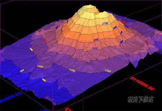
3DField is a contouring surface plotting and 3D data program that runs under Microsoft Windows NT/XP/Vista/7. 3DField converts your data into contour maps and surface plots. All aspects of 2D or 3D maps can be customized to produce exactly the presentation you want. The software component SWLib and others are available.
�ٷ��Wվ��http://www.3dfmaps.com/

63.21 MB / 2021/10/3

5.51 MB / 2021/9/16

56.41 MB / 2021/9/15

59.23 MB / 2021/9/8

2.33 MB / 2021/8/24

1.67 MB / 2021/6/24

6.8 MB / 2021/6/11

2.91 MB / 2021/6/7
- ��Xܛ���̳�ABC���D���_���؈DƬ/���s�DƬ�̳�
- ��Xܛ���̳����D���鿴���؈DƬ�ļ��̳�
- ��Xܛ���̳�Honeyview�鿴���؈DƬ�ļ��̳�
- ��Xܛ���̳�A1�Wվ�؈D������A1 Sitemap Generator���b...
- ��Xܛ���̳����D����һ�I�ı��؈DƬ�ߴ�̳�
- ��Xܛ���̳�LocaSpace Viewerע�����Ñ��~̖�̳�
- ��Xܛ���̳�С�������ı�����/���뱾�؈DƬ�̳�
- ��Xܛ���̳��^���������Ӛ��؈D�YԴ���Y�ֲ��D�̳�
- ��Xܛ���̳��Ϙ���ɼ��ɼ��؈D������Ϣ�̳�
- ��Xܛ���̳����D�����������������؈DƬ�̳�
- �� 0 �l�uՓ��ƽ�� 0 �� �ҁ��f�ɾ�
- �˚�Ӣ�������d�ٷ����d
- ��Ӣ���ˡ�(���QLOL)��������ȭ�^�Α�(Riot Games)�_�l���Ї���ꑵ^�vӍ�Α�����\�I��Ӣ�ی���MOBA... [�������d]
- ���u�ٶ�ƴ��ݔ�뷨 5.5.5025.0 �ٷ���
- �ٶ�ݔ�뷨�ǰٶ��Ƴ���һ����Xݔ��ܛ�����{��ٶ��������ƶ˼��g��֧�֣��ٶ�ݔ�뷨�ܿ�ͳɞ����X�Ñ�... [�������d]